- Tag
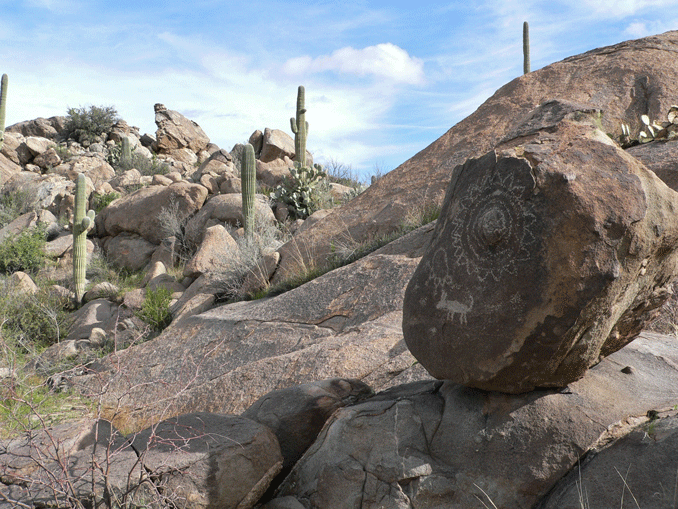
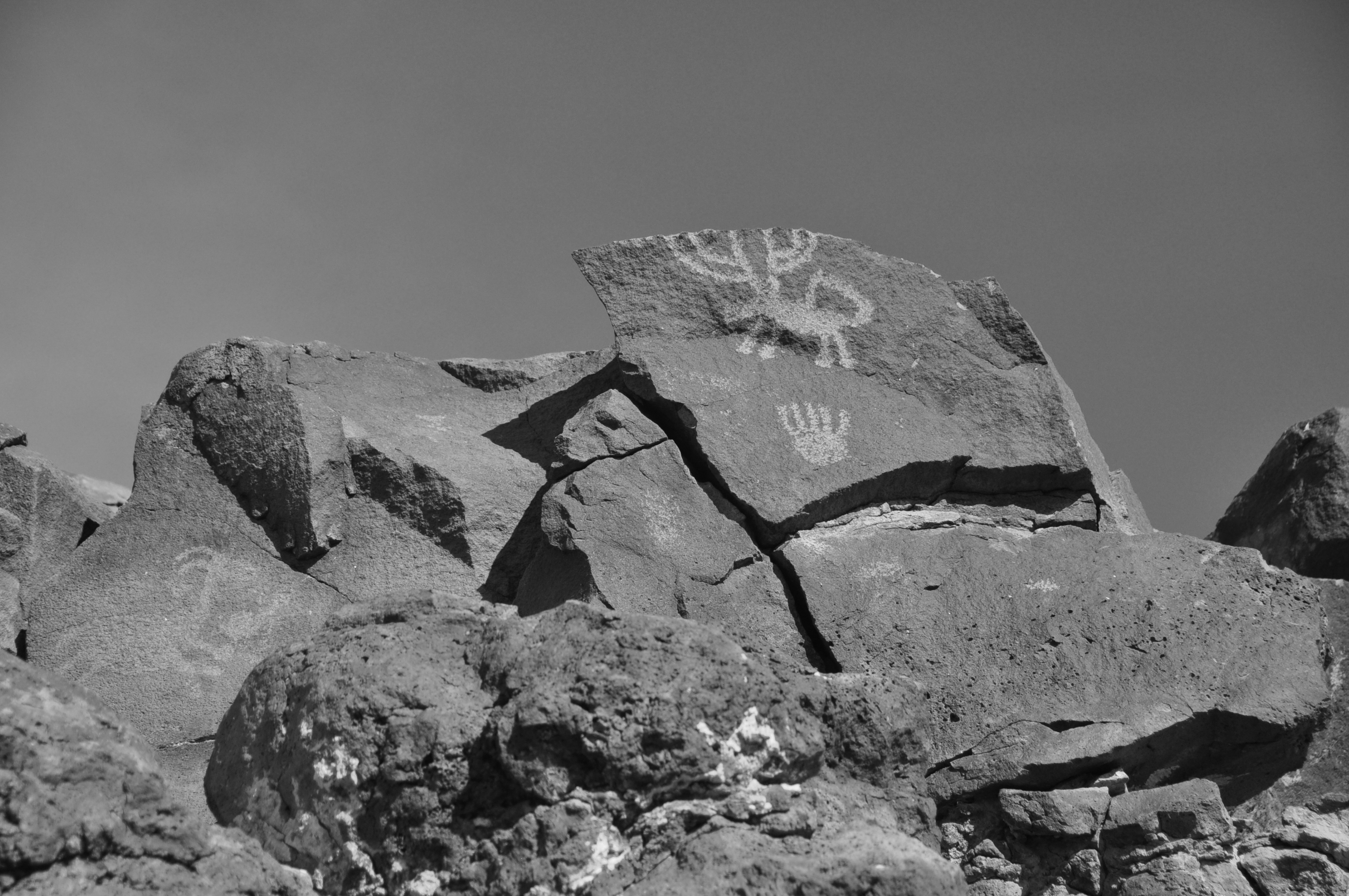
A place of special significance to the late Preclassic Hokokam is located at the base of the western slope of the Santa Catalina Mountains near Tucson. Taken in context with other anthropological information, it appears that Sutherland Wash Rock Art District was a ceremonial place with emphasis on the Uto-Aztecan Flower World. Flowers hold special meaning to speakers of Uto-Aztecan languages representing a spiritual landscape, a flowery, colorful, glittering paradise, that can be evoked through prayers, songs and other human actions. Previously reported in kiva murals and ceramics, Jane H. Hill suggested that such imagery might also be found in rock art.
A rich set of data recently created by a team of volunteers from AAHS and the Arizona Site Stewards includes a detailed recording of 3,251 prehistoric petroglyphs, a variety of surface features, artifacts, trails, solar markers and the results of a rudimentary acoustic experiment. In these data we found three important lines of evidence suggesting the special significance of Sutherland Wash. The first is the Flower World complex which is evident not only in petroglyphs representing both realistic and abstract flowers but also in glyphs depicting important related imagery including birds and butterflies. Second, the importance of gender is apparent in many male and female anthropomorphs, vulva forms, family groups, birthing scenes, and a landscape that includes yoni and phallus formations. Third, the interaction of sunlight and shadows with some of the panels clearly marked the equinoxes and solstices; one panel is a compelling horizon marker at the summer solstice involving Romo Peak where copper bells of Mesoamerican origin were found in the 1940s.
Utilized for centuries by many cultures, the National Register Sears Point Archaeological District (SPAD) is located along the rich riparian habitat of the Gila River. Currently managed by the Yuma District of the Bureau of Land Management, a large portion of the District is designated an Area of Critical Environmental Concern and is still utilized by several of the 15 Tribes that claim cultural affiliation there.
Responding to a BLM request for comprehensive rock art recording, Rupestrian CyberServices and Plateau Mountain Desert Research not only mapped approximately 2000 petroglyph panels and 100 features including rock piles, rock rings, artifact scatters, a rock shelter, several apparent natural and constructed hunting blinds, geoglyphs, and scattered rock alignments; but also, many historic features and an extensive network of pre-historic, historic, and animal trails. Recording and photographing SPAD required a three-year effort with the help of 50 volunteers, and some unusual techniques.
Tucson Balloon Rides assisted us by providing a low-elevation flight path from which we observed and photographed subtle features that were otherwise difficult to view from the ground and impossible to discern from available aerial photography.
Extensive measurements were made and recorded on multiple page forms during 16 weeks of fieldwork and subsequently entered into FileMaker Pro and Excel databases. 18,000 photographs are catalogued and identified by panel number in a Portfolio image database.
This presentation will provide not only a birds-eye view of the area, but also some intriguing petroglyph designs and preliminary analyses of the 8000 individual rock art elements.

WAITING LIST ONLY
Tumamoc Hill just west of the Santa Cruz river in downtown Tucson is a trincheras site with occupations going back to 500 BC. There are also a large number of Hohokam petroglyphs. Our leaders will be Hohokam scholars Paul and Suzanne Fish and Peter Boyle and Gayle Hartmann who led the AAHS rock art recording project on the hill. To register email Katherine Cerino. The trip is limited to 30 people.
Evelyn Billo and Robert Mark have been leading a multi-year effort to document the extensive rock art along the Gila River between Gila Bend and Yuma. President’s Weekend they will lead a trip for AAHS to see some of sites. We will meet in Gila Bend at 10:00 am on Saturday, February 18th and proceed to the Howard Wells site which is about an hour beyond Gila Bend. On Sunday we will go to the Sears Point site. We plan to leave Sears Point around 3:00 on Sunday so should be home by 6:00 p.m. We will have two or three leaders so we can split into groups based on walking ability and desire. There is a great deal to see without extensive hiking and a great deal to see which involves hiking. We will plan to spend the night in Gila Bend although primitive camping maybe available at the Howard’s Well Site. Camping is no longer allowed at Sears Point. High clearance vehicles are required so we will carpool from Gila Bend. To register for the trip contact kcerino@gmail.com and indicate if you have a high clearance vehicle.

- Sears Point

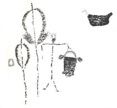
Ancient bags are depicted in Southwestern rock art and have been recovered from many archaeological sites in the region. Despite their widespread presence in the prehispanic Southwest, little research has been conducted on their styles, archaeological contexts, and uses. Ethnographic research suggests they served as medicine bags, as containers for tool kits and foodstuffs, or simply to haul things around. In indigenous Mexico and Guatemala, woven bags are traditionally a man’s accessory and often a male product. What is the evidence for their use and production in the U.S. Southwest?
In this presentation, a rock-art researcher and an archaeological perishables specialist team up to explore a variety of questions related to bags. How are they depicted in rock art? What forms are portrayed? In what contexts do they occur? What kinds of archaeological examples survive in museum collections, how were they made, and what did they contain? Taken together, what do these multiple lines of evidence suggest about the uses of bags in the ancient Southwest?
Drawing from rock art images from the San Juan River corridor of southeastern Utah, depictions from other regions, the Southwestern archaeological literature, and ethnographic information from other parts of the world, we embark on a visual and cultural exploration of this rarely considered, but always ubiquitous, item of material culture.

Rock art is notoriously difficult to date and some dating techniques used for dating have been proven unreliable leading to considerable confusion in the literature on what is old and what is not. Using the best available dating of ancient rock art in western North America, I will discuss the present state of knowledge and present a visual perspective on the earliest styles and what they may tell us about the people who made them. Three significant styles or substyles are noted that date prior to the time of Christ. I will provide evidence for what people were doing at these early sites and consider who was making the designs and how often they were doing so. Included in the talk will be the first public presentation of data on a recently verified depiction of a mammoth and possible related Pleistocene megafauna.